
Kajian Spasial Dampak Alih Fungsi Lahan terhadap Risiko Banjir dan Implikasinya Pada Ketahanan Pangan: Studi Kasus DAS Krueng Keureuto (Spatial Study Of The Impact Of Land Use Change To Flood Risk and Its Implication on Food Security: A Case Study Of The Krueng Keureuto Watershed)
DOI:
https://doi.org/10.59465/jppdas.2026.10.1.45-62Keywords:
Spatial study, Land use change, Flood discharge, Rice production, Krueng KeureutoAbstract
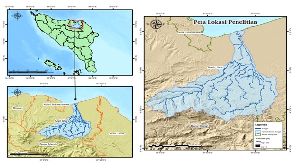
The dynamics of land use change trigger regional vulnerability to flooding during the rainy season. Increased peak flood discharge has the potential to inundate rice fields, ultimately reducing rice productivity and threatening food security. In line with these issues, this study was conducted to spatially examine the relationship between land use change and increased flood discharge and as well as its implications for the flood-affected rice field areas that influence rice production in the Krueng Keureuto Watershed. The dynamics of land use change were assessed through spatial analysis based on multi-temporal satellite imagery processed using ArcGIS, and discharge data obtained through hydrological modeling with HEC-HMS. Furthermore, flood modeling was conducted to evaluate the extent of the affected areas. The modeling results were then integrated with rice production data to determine the impact of land use change on rice production. Based on the analysis, land use change has implications for an increase in the Curve Number (CN) value, followed by an average increase in flood discharge of 5.04%. Within a 13-years, rice field areas in the Krueng Keureuto Watershed have decreased by 1,077 ha, with a potential reduction in rice production of 6,526.62 tons of due to land conversion, exacerbated by widespread flooding in the remaining productive rice fields. Therefore, land-use control and upstream rehabilitation based on spatial technology, along with collaborative spatial planning policies, are required to maintain sustainable rice production.
Downloads
Published
How to Cite
Issue
Section
License
Copyright (c) 2026 Jurnal Penelitian Pengelolaan Daerah Aliran Sungai (Journal of Watershed Management Research)

This work is licensed under a Creative Commons Attribution-NonCommercial-ShareAlike 4.0 International License.


